
Geonode Server
Your geospatial environment is in capable hands.
Open Source Geospatial Content Management System
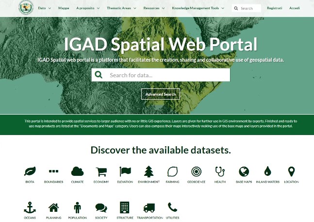
GeoNode is a web-based application and platform for developing geospatial information systems (GIS) and for deploying spatial data infrastructures (SDI).
 4.7 out of 5 stars based on 47 reviews|
Geonode
The quickest way to start
You can choose from multiple locations
Germany gives best performance for Pakistan users.
GEONODE BASIC
- 500 GB (NVMe SSD) Storage
- 12 CPUs (Hexa Core)
- 64 GB DDR4 RAM
- 1 Gbps Network
- Unlimited Bandwidth
- Unlimited Users
- GeoNode Latest Version
- Performance Tuning
- Expert Support
- Enterprise Security
- Ticketing Portal
- Backups
GEONODE PRO
- 1.5 TB (NVMe SSD) Storage
- 12 - 24 CPUs
- 64 - 128 GB (ECC) RAM
- 1 Gbps Network
- Unlimited Bandwidth
- Unlimited Users
- GeoNode Latest Version
- Performance Tuning
- Expert Support
- Enterprise Security
- Ticketing Portal
- Backups
GEONODE PREMIUM
- 2.5 TB (NVMe SSD) Storage
- 12 - 24 CPUs
- 64 - 128 GB (ECC) RAM
- 1 Gbps Network
- Unlimited Bandwidth
- Unlimited Users
- GeoNode Latest Version
- Performance Tuning
- Expert Support
- Enterprise Security
- Ticketing Portal
- Backups
GEONODE ENTERPRISE
- 4 TB (NVMe SSD) Storage
- 12 - 32 CPUs
- 64 - 128 GB (ECC) RAM
- 1 Gbps Network
- Unlimited Bandwidth
- Unlimited Users
- GeoNode Latest Version
- Performance Tuning
- Expert Support
- Enterprise Security
- Ticketing Portal
- Backups

More Geo Spatial Data
GeoNode makes it simple to view, process, upload, and share maps and geospatial data within an integrating social network collaboration platform. Geospatial tools...

Import & Manage Data
GeoNode simplifies the upload and management of geographical data on the web. Any user can upload and publish material using standard OGC protocols such as Web Map Service (WMS) and Web Feature Service (WFS). Data can be browsed, searched, styled, and processed to create maps that can be shared publicly/privately.

Internactive Online Maps
GeoNode includes cartography tools for graphically decorating and creating maps. These tools make it simple for anyone to create a web-based mapping application that includes capabilities often seen on desktop GIS systems.
Open Source Geospatial Software
Speed you need! lets get you started
GeoNode delivers all of the functionality required to build a comprehensive GIS platform, including data and metadata management, as well as quick mapping capabilities that allow users to move from raw information to maps, dashboards, and geo-stories with minimal work. GeoNode is used by organizations all over the globe to quickly build up a geospatial infrastructure that allows users to ingest, share, explore, preview, visualize, and distribute data. GeoNode provides users with the piece of mind that the project is open source, ensuring that it will remain open in perpetuity.
Whether you want to move away from proprietary products or create a hybrid geospatial platform that combines proprietary and open source products, Geonode Solutions has unparalleled expertise in building enterprise-class GIS mapping and analysis web platforms based on best-of-breed open source geospatial frameworks like GeoServer, GeoNetwork, GeoNode, and MapStore.
Choose open source to save money on licensing, increase your support for open standards, and provide opportunities for simpler customization. It's never been easier to make a change!
You get the following...
Rest assured that your deployment will remain fully functional under our watchful eye. Our team's unparalleled expertise and extensive experience with GeoServer, GeoNode, MapStore, and GeoNetwork allows us to confidently guarantee that your deployment will not break. In the unlikely event that it does, we stand behind our promise to fix it promptly and at no additional cost to you. With our comprehensive package, your firm can rest easy knowing that your open source investment is being safeguarded and optimized for continued success.
Who Uses GeoNode?
GeoNode is the platform of choice for organizations that need to collect, manage, visualize, and share geospatial data — from global NGOs to government agencies and universities.
UNDP, USAID, FAO, UNICEF, and World Bank projects in Pakistan use GeoNode to manage field survey data and project mapping portals.
Provincial and federal government bodies use GeoNode for spatial data infrastructure, disaster risk mapping, and urban planning portals.
Academic departments and research labs deploy GeoNode to publish geospatial research datasets and collaborative GIS mapping tools.
Environmental consultancies and GIS firms use GeoNode as their client-facing spatial data sharing and visualization platform.


The Only Pakistani Provider for Managed GeoNode Hosting
Nextgen Hosting is Pakistan's specialist in managed open-source geospatial platforms. Our team has hands-on expertise with GeoNode, GeoServer, PostGIS, and GeoNetwork — built through years of real-world deployments.
We configure GeoServer, PostGIS, NGINX, and SSL — everything pre-tuned for production performance from day one.
24/7 infrastructure monitoring with guaranteed incident response. If GeoNode goes down, we fix it — no additional cost.
Pay in Pakistani Rupees via JazzCash, EasyPaisa, bank transfer, or credit card. No foreign exchange hassle.
Choose from Germany, UK, USA, Singapore, Japan, or Australia. Germany offers the best latency for Pakistan users.
Frequently Asked Questions
Everything you need to know about our managed GeoNode hosting service.
What is GeoNode and what can it do?
GeoNode is an open-source web-based application for developing geospatial information systems (GIS) and spatial data infrastructures (SDI). It allows organizations to upload, share, and visualize maps and geospatial datasets, build interactive map applications, and collaborate on geospatial projects — all through a web browser.
Do you support GeoServer and PostGIS alongside GeoNode?
Yes. All our GeoNode deployments come pre-configured with GeoServer (for OGC map services like WMS and WFS) and PostGIS (PostgreSQL with geospatial extensions). We can also set up GeoNetwork for metadata catalog management on request.
Can I import Shapefiles, GeoTIFF, and other geospatial formats?
Absolutely. GeoNode supports uploading Shapefiles (.shp), GeoTIFF, KML, CSV with coordinates, and GeoJSON. Our team can also assist with large dataset imports and GeoServer layer configuration for complex datasets.
What locations are available for my GeoNode server?
We offer server locations in Germany, UK, USA, Singapore, Japan, and Australia. For Pakistani organizations, Germany typically provides the best balance of latency and cost. We recommend discussing your specific needs with our team to choose the optimal location.
How do I get started with a managed GeoNode server?
Simply contact our team via the button above or email [email protected]. We'll assess your requirements (data volume, expected users, required integrations), recommend the right plan, and handle the full deployment and configuration for you — typically within 24–48 hours.
Are backups included in the GeoNode plans?
Yes. All plans include automated backups. Cloud plans include 2–4 weekly backups, while dedicated server plans include daily backups with longer retention. Custom backup schedules are available on Enterprise plans.